![]()
![]()
Introduction
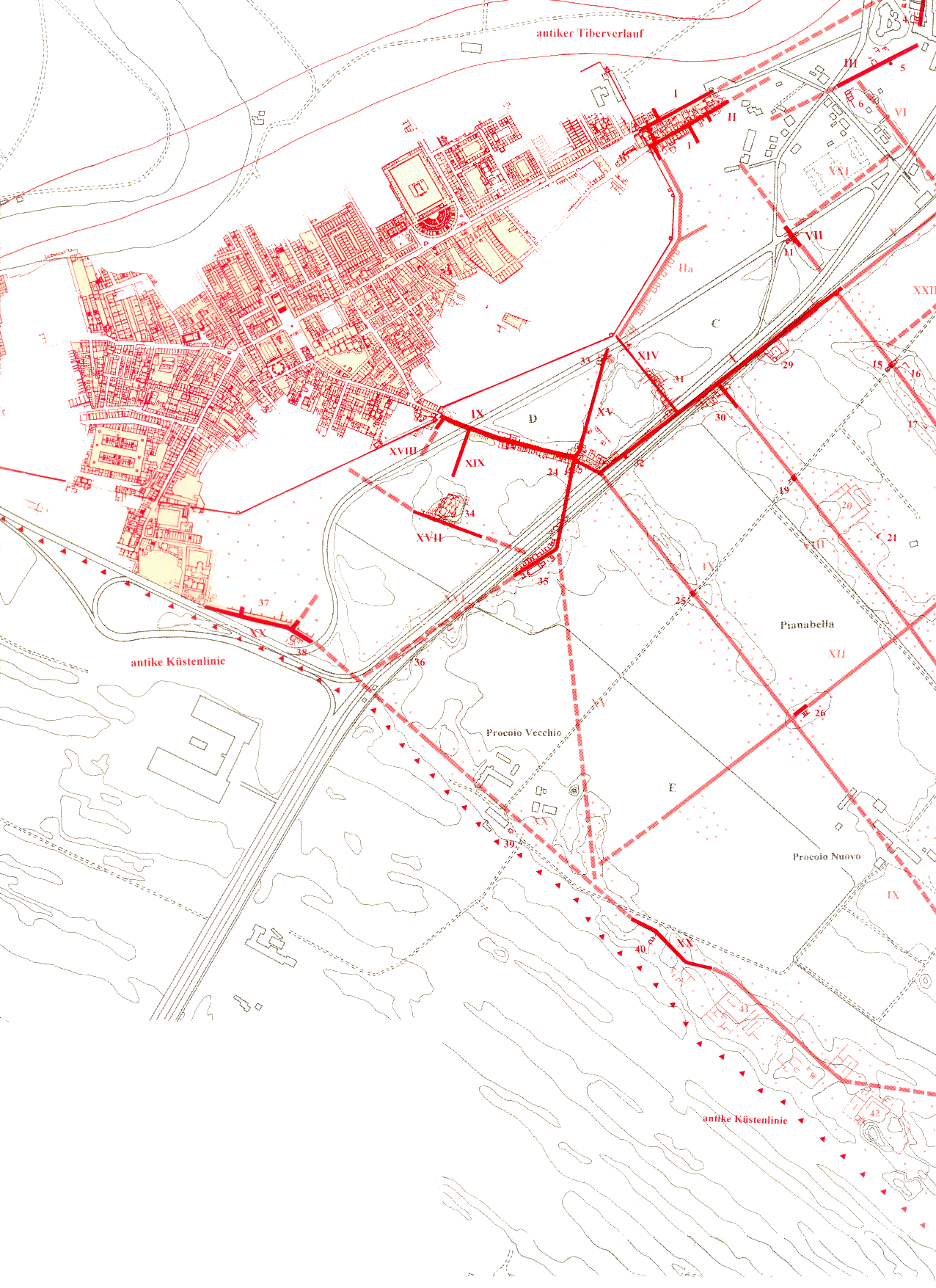
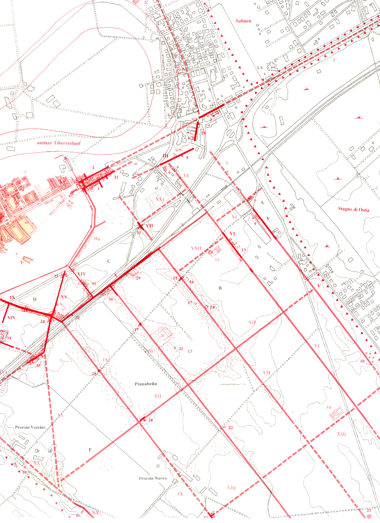
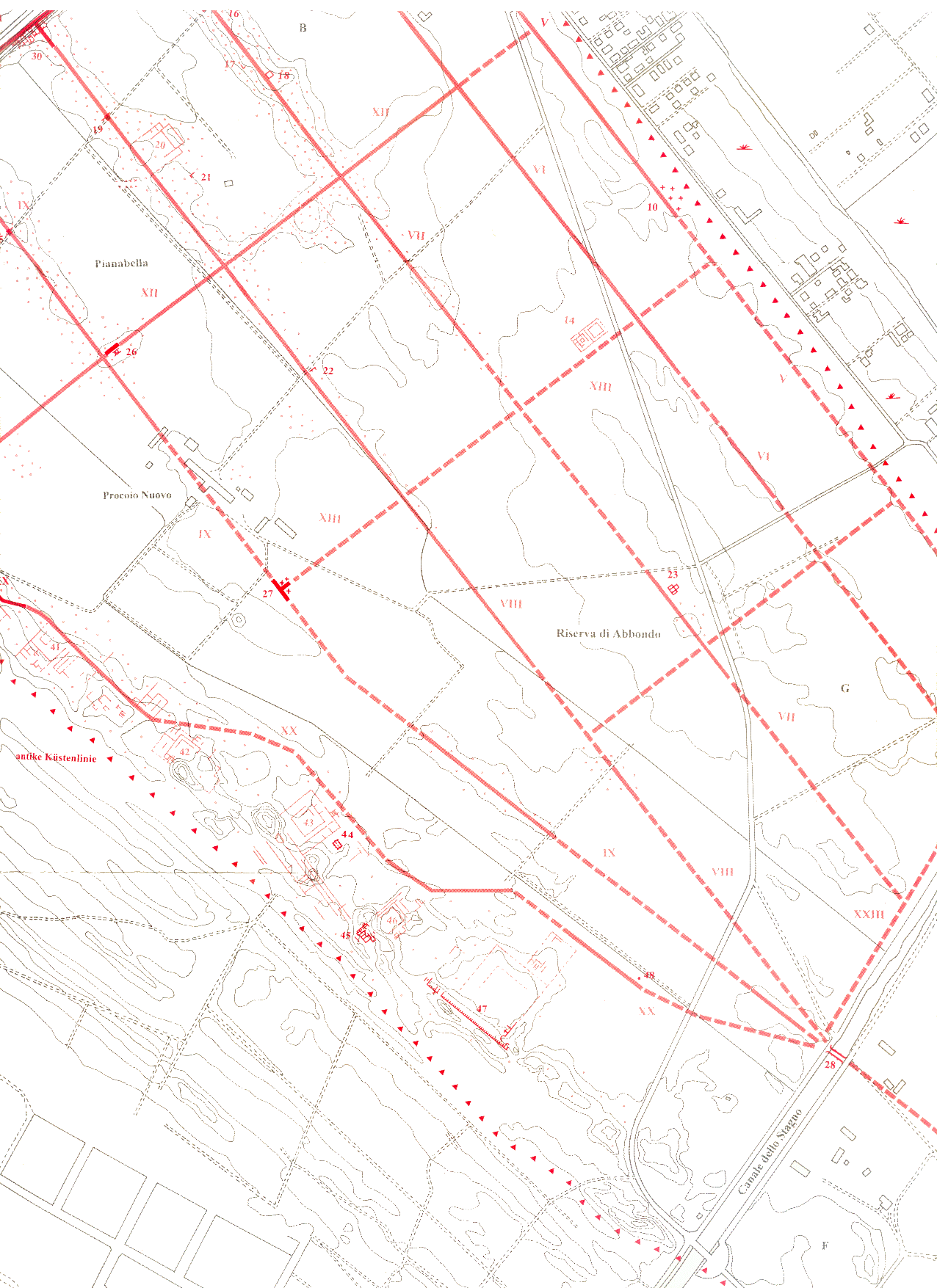
Important studies for the area to the south and east of Ostia were published in 1957 by John Bradford, who looked at the geology, and in 1998 by Michael Heinzelmann, who combined geophysical and archaeological data. The area is for the most part taken up by a plain known as Pianabella, "Beautiful plain". A detailed map of the area was published by Heinzelmann and is shown below (click on an image to enlarge it).
 |
 |
 |
 |
|
Click on an image to enlarge. Top left: map of the north-west part of the Pianabella. Top right: map of the area to the east of Ostia, and of the north-east part of the Pianabella. Right: map of the south part of the Pianabella. Legenda of the map (opens in a new window). |
To the north of Ostia was the Tiber. In antiquity the river continued further to the east than it does today. It reached the spot of the mediaeval borgo (modern Ostia Antica), where it turned towards the north. This arm was cut off during an inundation in 1557. It is now filled with earth and called Fiume Morto, "Dead River". Further to the east was a lagoon or swamp, the stagnum Ostiense. The north part of the swamp was taken up by salt pans. The Via Ostiensis, leading from Ostia to Rome, traversed the swamp and therefore had to be raised and reinforced with supporting walls and special foundations. The salt water reached the salt pans through narrow channels below the Via Ostiensis. An aqueduct ran parallel to the road.
The area between Ostia and the swamp, but in particular the plain to the south of Ostia, is today called Pianabella, "Beautiful plain". The size of the plain is approximately 1.5 x 2.5 km. The western border of this plain was the sea, with a sand beach and dunes, behind which were villas. Starting in the Middle Ages and until the 19th century the coastline moved several kilometers to the west, due to the depostion of silt by the Tiber. The present beach is four kilometers to the west. The location of the mouth of the Tiber in the years 14 AD, 850, 1569, 1774 and 1876 is indicated on Bradford's map below. The southern border of the plain is the present day Canale dello Stagno, "Channel of the Swamp", which already in the Roman period connected the swamp and the sea.

|
The plain to the south and east of Ostia ("Pianabella"). Bradford 1957, fig. 23.
Excavations in the 19th and 20th century, and a study of crop marks, of undulations in the terrain, and of aerial photos have led to the discovery of an orthogonal system of many Roman roads on the Pianabella. The system consisted of five roads running north-west / south-east, and many side-streets running south-west / north-east. They seem to have been created in the Augustan period. Along the coast ran the Via Severiana, built around 200 AD by the Severan Emperors. The roads were eventually all paved with basalt blocks, for the last time in the Severan period. Two of the north-west / south-east running roads and the Via Severiana led to a bridge across the Canale dello Stagno. Many of the roads were flanked by tombs, but remains have also been identified of buildings related to agricultural use, such as farms and little storage buildings.

One of five high ridges on the Pianabella, directly to the south of Ostia.
In the ridges are the remains of north-south running roads. Photo: Jan Theo Bakker.

|
The "areas of crop-marks showing buried roads, buildings, etc." on Bradford's plan. Photo: Google Earth, May 2020.
![]()
![]()