Introduction
The Via Ostiensis started to the west of the Aventine, near the Tiber. Here we will start following the road from the Porta Ostiensis, today called Porta San Paolo, which was part of the wall of Aurelianus. Imperial officials were responsible for the road, together with the Via Campana on the other side of the Tiber. From the end of the 2nd century we have a procurator viae Ostiensis et Campanae, M. Bassaeus Axius, and from the 2nd or 3rd century a curator viarum Ostiensis et Campanae, T. Flavius Rufinianus.
The road was flanked by tombs, but also by villas and farms. An inscription dated 25 July 227 AD documents a petition by a certain Geminius Eutyches. He is a farmer of vegetable gardens located on the Via Ostiensis (colonus hortorum olitoriorum qui sunt Via Ostiensi), for which he pays an annual rent of 26.000 sesterces, a considerable amount, indicating a large terrain. The land is owned by the collegium magnum arkarum divarum Faustinarum, the "large guild of the treasuries of the divine Faustinas", the wives of Antoninus Pius and Marcus Aurelius. The guild had been instituted for the sustenance of poor families with female children, the puellae Faustinianae. Eutyches asks a president (quinquennalis) to plead for permission by the guild to erect a small tomb in the gardens, at the foot of a hill (memoriola sub monte). If permission is granted (and it is), then he will thank the Genius of the president. The inscription was found on the Via Ostiensis, but unfortunately the precise spot is not known.

|
PORTA OSTIENSIS |
The Porta Ostiensis was part of the wall of Aurelianus, built in the later 3rd century. Various modifications took place afterwards, especially by Honorius in the early 5th century. The gate is called Porta Ostiensis by Ammianus Marcellinus in the 4th century, when he describes the transport of an obelisk for the Circus Maximus through it. In the 6th century Procopius of Caesarea already calls it "the gate which bears the name of the apostle Paul", when he describes how he secretly left Rome through the gate during the Gothic War. In the Cosmographia of Aethicus we hear of the Ostensem portam, quae est domni Pauli apostoli. The gate is today still called Porta San Paolo, because from here the road leads to the basilica of Saint Paul outside the Walls.

The gate seen from the outside. Photo: Wikimedia.
Outside the gate was a necropolis, the most famous monument of which is the Pyramid of Caius Cestius. It was built in the late 1st century BC.

The pyramid and gate on a drawing by Giuseppe Vasi (1747).
SAINT PAUL OUTSIDE THE WALLS |
The most famous burial in the necropolis outside the gate was that of Paul. The construction of the basilica over his grave was started by Constantine and continued, later in the 4th century, by Theodosius. A fire destroyed almost the entire building in 1823. The current and completely new basilica was opened in 1840. The nickname of the campanile (from 1860) is "il faro", and the model for it was the lighthouse of Portus.
Paul may have walked on the Via Ostiensis, from Rome to Ostia. In his letter to the Romans he wrote: "But now that there is no more place for me to work in these regions, and since I have been longing for many years to visit you, I plan to do so when I go to Spain. I hope to see you while passing through and to have you assist me on my journey there, after I have enjoyed your company for a while. ... I will go to Spain and visit you on the way" (Letter to the Romans 15:23-29; probably written in 56 or 57 AD). Whether Paul really had the opportunity to go to Spain is much disputed, but it was believed by Christians in the second half of the 2nd century. The apocryphal Acts of Peter, written in this period, describe his journey from Rome to Ostia along the Via Ostiensis, and his departure from Ostia: "A great multitude of women were kneeling and praying and beseeching Paul, and they kissed his feet and accompanied him unto the harbour. But Dionysius and Balbus of Asia, knights from Rome, and illustrious men, and a senator by name of Demetrius abode by Paul on his right side and said: 'Paul, I would desire to leave the city if I were not a magistrate, that I might not depart from thee.' Also from Caesar's house, Cleobius and Iphitus and Lysimachus and Aristaeus and two matrons Berenice and Philostrate with Narcissus the presbyter accompanied him to the harbour. But whereas a storm of the sea came on, he (Narcissus?) sent the brethren back to Rome, that if any would, he might come down and hear Paul until he set sail; and hearing that, the brethren went up unto the city. And when they told the brethren that had remained in the city, and the report was spread abroad, some on beasts, and some on foot, and others by way of the Tiber came down to the harbour, and were confirmed in the faith for three days, and on the fourth day until the fifth hour, praying together with Paul, and making the offering. And they put all that was needful on the ship and delivered to him two young men, believers, to sail with him, and bade him farewell in the Lord and returned to Rome".
It is tempting to think that Paul teached in the synagogue of Ostia, which has been ecavated, and was perhaps built around 50 AD. Later stories place Paul in Tarraco (Tarragona) and Dertosa (Tortosa). But there might be more to connect Paul and Ostia. In 1867 a funerary inscription was found, in the necropolis to the south of the Porta Laurentina, with the text:
|
D(is) M(anibus) M(arco) ANNEO PAVLO PETRO M(arcus) ANNEVS PAULVS FILIO CARISIMO |
To the spirits of the dead. For Marcus Annaeus Paulus Petrus. Marcus Annaeus Paulus, For his most beloved son. |
 |
 |
| The inscription found in 1867 in a necropolis of Ostia. | A Spanish stamp issued in 1963.
XIX CENTEÑARIO DE LA VENIDA DE SAN PABLO A ESPAÑA. 19TH CENTENARY OF THE COMING OF SAINT PAUL TO SPAIN. |
The quality of the letters suggests a date at the end of the 1st century or in the first half of the 2nd century. What is striking in the inscription is not the name of the father (Paulus was a common name), but the double name of the son: Paulus Petrus. This suggests a strong Christian conviction. The pagan phrase D(is) M(anibus) seems to contradict this, but these two letters seem to have been made by a different hand (in other words: the inscription was "prefabricated", in stock). Some would like to go a step further. The inscription has evoked as much debate as Paul's stay in Spain. At the background is the idea that, in Rome, Paul had met Lucius Annaeus Seneca, the stoic philosopher and tutor of Nero, and that they had become friends. Seneca had a brother called Marcus Annaeus Gallio. Marcus Annaeus Paulus in the inscription belonged to the "clan" (gens) of the Annaei; perhaps he was a freed slave. In other words, the insciption would be evidence of a certain Christian tendency in the gens of Seneca. I collected (parts of) some articles about this topic.
PONTICELLO DI SAN PAOLO |
About 750 metres down the road we reach a place called Ponticello di San Paolo. This is where an ancient road presumably branched off (today below a railway viaduct), leading to the Via Laurentina further to the east. This road in turn led to the area of the legendary city of Laurentum. The side road is today also called Via Laurentina.
Not far to the east are the Catacombs of Santa Tecla. Here, in 2010, portraits were found of three apostles and Paul, dated to the late 4th century.
 |
 |
||
 |
 |
||
| The portraits of John and Andrew, and Peter and Paul in the catacombs of Santa Tecla. | |||
TOR DI VALLEBRIDGE |
At Tor di Valle the remains of a Roman bridge can still be seen. Between Rome and Acilia the road made use of eight small bridges, spanning narrow tributaries of the Tiber coming from the east. They were mostly destroyed between 1927 and 1995. They were made of tuff blocks with a travertine keystone, and had a width of 7 metres. Later on, between Acilia and Ostia, we will also encounter two viaducts. The bridges and viaducts have been assigned to three periods: the first half of the second century BC; the middle of the first century BC, possibly contemporaneous with the construction of the city walls of Ostia by Cicero; the Augustan period. Restorations have been dated to the Severan period and to c. 600 AD.


The bridge at Tor di Valle. Images: YouTube and Google Maps.
VITINIA |
Near Vitinia, to the east of the Via Ostiensis and in the pine forest Pineta di Risaro, a villa was found. Nothing is known about the excavation, that must have taken place before 1923. Some rooms were decorated lavishly, there were bathing rooms, but an oil press was also found. A black-and-white mosaic from the building, taken to the Museo Nazionale Romano in 1947, is reminiscent of the well-known mosaic in the Baths of Neptune in Ostia. Neptune, Nereids and sea creatures are depicted. The mosaic measures 6.60 x 6.60 m.
 | |
 | |
| Top: Aurigemma 1961, fig. 10. Center: Aurigemma 1961, fig. 11. Bottom right: Di Mino 1975, fig. 1. |
 |
VIA DI MALAFEDE |
Just before reaching Acilia, another road leading to the Via Laurentina branches off, today called Via di Malafede (the Malafede is one of the larger tributaries of the Tiber). Pliny the Younger had a villa on the coast to the south of Ostia, and could use the Via Ostiensis and this side road to reach it. This is what he says about the journey to the coast (translated by B. Radice):
"You may wonder why my Laurentine place (or my Laurentian, if you like that better) is such a joy to me, but once you realize the attractions of the home itself, the amenities of its situation, and its extensive sea-front, you will have your answer. It is seventeen miles from Rome, so that it is possible to spend the night there after necessary business is done, without having cut short or hurried the day's work, and it can be approached by more than one route; the roads to Laurentum and Ostia both lead in that direction, but you must leave the Laurentine at the fourteenth milestone and the Ostian at the eleventh. Whichever way you go, the side road you take is sandy for some distance and rather heavy and slow-going if you drive, but soft and easily covered on horseback. The view on either side is full of variety, for sometimes the road narrows as it passes through the woods, and then it broadens and opens out through wide meadows where there are many flocks of sheep and herds of horses and cattle driven down from the mountains in winter to grow sleek on the pastures in the springlike climate."
"The woods close by provide plenty of firewood, and the town of Ostia supplies us with everything else. There is also a village, just beyond the next house, which can satisfy anyone's modest needs, and here there are three baths for hire, a great convenience if a sudden arrival or too short a stay makes us reluctant to heat up the bath at home. The sea-front gains much from the pleasing variety of the houses built either in groups or far apart; from the sea or shore these look like a number of cities. The sand on the shore is sometimes too soft for walking after a long spell of fine weather, but more often it is hardened by the constant washing of the waves. The sea has admittedly few fish of any value, but it gives us excellent soles and prawns, and all inland produce is provided by the house, especialy milk: for the herds collect there from the pastures whenever they seek water and shade."
The eleventh milestone, mentioned by Pliny, has actually been found near the intersection. It can be dated to c. 230-200 BC:
 |
 XI C(aius) CINCI(os) Q(uintus) [---] AIDELE(s) P(ublius) [---] PLEIB(ei) PROBAVE[r]O(nt) The eleventh milestone. Photo: Lorenzatti 2007, fig. 8. Drawing: CIL VI, 31585. |
ACILIA - MALAFEDEAQUEDUCT |
Many remains of the Ostian aqueduct were found on either side of the Via di Malafede, to the south-east of the Via Ostiensis, about 9 kilometres to the north-east of Ostia itself. It is referred to in the publications as locality Casale di Malafede and locality Malafede-Infermeria. The aqueduct was partly above ground and partly underground. The source has hypothetically been placed at locality Trigoria, about 8 kilometres to the east of the intersection of the Via Ostiensis and the side road, as the crow flies.
Traces of the aqueduct were excavated already in 1912 - together with stretches of the Via Ostiensis, 4.80 metres wide -, and in 1916. An underground stretch was found, running to the south-east of and parallel to the Via Ostiensis, at a distance of 80 metres. Nearby, similar remains were found in 1998. In the 1990's remains were actually found of two parallel aqueducts, right next to each other, but also intersecting at one spot. Still, they may have been functioning simultaneously.
The aqueduct was constructed in the 1st and 2nd century AD, while restorations were carried out in the early 3rd century. It was in use at least as late as c. 400 AD.
Map of the environs of Ostia and Portus, with the location of remains of the aqueducts of (top to bottom)
Portus, Ostia and Laurentum. The Malafede area is 2a, b, c. From Bedello Tata - Bukowiecki 2006, fig. 1.

The two intersecting aqueducts. From Bedello Tata - Bukowiecki 2006, fig. 17.
ACILIA- FRALANA - CASAL PALOCCOTOMBS |
In the Acilia area many tombs have been excavated, near the Via Ostiensis, but also further to the east. There, thiry burials were excavated at locality Villa di Fralana. They have been dated to the 2nd to 4th century. The deceased must have worked in neighbouring farms.

Burials of the Fralana necropolis. From Falzone - Olivanti - Pellegrino 2001, figs. 2-3.
Further to the south, at locality Casal Palocco, a truly exceptional discovery was made in 1950. In a field fragments were discovered of an exceptionally large sarcophagus. No remains of a tomb were found, so the fragments were probably near a lime kiln, but the sarcophagus will not have been moved very far. It is now in the Museo Nazionale in Rome. The first detailed study was written by Ranuccio Bianchi Bandinelli.
There are many traces of the colour red, but this is not paint, it is a primer for gilding. The clothes and hair of all figures were gilded. A clear contrast was created by polishing the faces. In the centre of the main side (on the photo on the far right) are a man and a woman (the woman is almost completely lost), the couple for which the sarcophagus was intended. To the left and right are groups of people: male to the left, female to the right. Scrolls (rotuli) in the hands of the men and standing on the floor characterize some of them as philosophers. The female group has been preserved badly, but they are probably the Muses. One of the male figures gestures towards a young man at the far left. The face of the latter is an individual portrait. Only his face and that of the deceased man were not polished.

The Acilia sarcophagus. The deceased man is at the far right. The prince is unbearded.
Photo: Frans Vandewalle.
The man making the gesture is the Genius Senatus, the protective deity of the Senate in Rome. The young man must be a prince, destined to become Emperor. A stylistic analysis shows that the sarcophagus was made in the first half of the 3rd century, and that only one of two princes can be meant: Gordian III or Philip the Arab. The role of the Senate in this turbulent period points to the former and the years 235-238 AD. In 238 AD Gordianus was made Augustus. Presumably his father, a senator, was buried in the sarcophagus. His name was perhaps Iunius Licinius Balbus. His mother was Antonia Gordiana (we also hear of the name Maecia Faustina). She was still alive during the first years of Gordianus' reign.
ACILIAVIADUCT |
< |
We now reach the center of modern Acilia, the area of the ancient settlement Ficana, which had disappeared completely already in the Imperial period. In the early 20th century the modern city was given this name by Dante Vaglieri, excavator of Ostia. He thus wished to commemorate the Ostian family of the Acilii, documented in an inscription that was found here in 1797: THIASVS ACILI GLABRION INPERATV ARAM FECIT DOMINAE ("Thiasus, slave of Acilius Glabrio, by a (divine) order, set up the altar for the mistress" (Bona Dea or Isis).
About 400 metres to the west of the station of Acilia (bus stop Romagnoli) part of a viaduct has been excavated in 1994. A stretch of 400 metres had been preserved, a small part of which was rebuilt on top of a modern tunnel, between a road and the railway. The viaduct needed to bridge a slope and some tiny streams. It consisted of two walls flanking a road that was 5 metres wide and covered with basalt blocks. The walls were made of large tuff blocks. Holes in the blocks testify to the use of large pliers to move them. Quarry marks can be seen. Many have an "opus rusticum" surface. On either side of the viaduct were tombs.

The remains of the viaduct. Image: Google Maps.
ACILIA - MONTI DI SAN PAOLOSYMMACHUS |
The hills of Acilia are called Monti di San Paolo, and it may well be here where, at the end of the 4th century, the Roman statesman Quintus Aurelius Symmachus had a villa. He fled to this villa when an uprising broke out in Rome at the hands of his political opponents. The estate was bordered by the Tiber, on the bank of which Symachus could look at the loading of ships, as he himself describes in his letters.
| Symmachus, Epistulae II,52,2 (388 AD) - the property of Symmachus is occupied by troops | |
| SYMMACHUS FLAVIANO FRATRI Dehinc ut apud vos familiarem curam loquamur, urget Ostiense praedium nostrum militaris inpressio. Nos legum inane nomen vocamus. Dii viderint exitum causae. Interea mordemur non metu damni, sed aequitatis iniuria. Collegarum tractatus qui me exciverat, aeternis principibus legandorum in Africam virorum reddidit optionem. Cessante ergo patrum deliberatione vacamus. Vale |
SYMMACHUS TO HIS BROTHER FLAVIANUS Then, to speak now to you about my domestic concerns, our domain at Ostia is overwhelmed under the weight of the troops. We can only invoke laws that remain a dead letter; to the Gods to bring our cause to fruition. In the meantime, what torments us is not the fear of damage, but the insult to the law. The debates of our colleagues who had provoked my arrival restored to our eternal Princes the choice of people to delegate to Africa. The Fathers therefore ceasing to deliberate, makes me free. Farewell. |
| Symmachus, Epistulae VI,72 (388 AD) - the property is being attacked | |
| SYMMACHUS NICOMACHI FILIIS Patriae ac penatibus redditi, quaedam quibus offenderemur invenimus: siquidem Ostiense praedium nostrum frequens pulsat inpressio. Sed si vobis prospere optata procedunt, praestate litteras, quarum laetitia nubem tergeat praesentis iniuriae. Vale |
SYMMACHUS TO HIS NICOMACHUS CHILDREN Returned to the city of our fathers and to our Penates, we discover what to be shocked about, because repeated assaults hit our land at Ostia. But if your projects have a happy outcome, give me the gift of a letter whose joy can erase the cloud of affronts today. Farewell. |
| Symmachus, Epistulae III,82 (389 AD) - loaded ships on the Tiber | |
| SYMMACHUS RUFINO Adhuc siles; sed loquacitas mea non cohibetur exemplo, et est otium mihi ad verborum copiam nimis commodum. Nam ruri sum nec tamen rusticor. Tantum de ripa Tiberis - nam per fines meos fluvius elabitur - onusta specto navigia, non iam sollicitus, ut ante, de fame civium. Ex inopia namque publicus metus versus est in gaudium, postquam venerabilis pater patriae Macedonicis commeatibus Africae damna pensavit. Quem nunc omnes ut altorem generis humani deum diligunt. Nihil enim passus est austris contumacibus adversum Romam licere. Ergo de agri mei specula peregrinarum navium numero transcursus, et gaudeo victum populi Romani non fato provinciarum sed voto principis regi. Scio haec in aures eius esse ventura devotione qua soles non occulere bonum publicum. Merito parcius loquor tuae facundiae relinquens, ut haec ornatius, si ita placebit, insinues, quae nos inculta veritate narravimus. Vale |
SYMMACHUS TO RUFINUS You continue to remain silent; your example, however, does not prevent me from enjoying chatting, especially since my leisure lends itself particularly to abundant remarks. I am in the fields but without the country soul. I am satisfied from the bank of the Tiber - the river flows along my property - to look at the loaded ships, and have no more, as before, concern for the provisioning of my fellow citizens. The general fear, born of scarcity, has indeed become joy, since the Father of the Fatherland, object of our veneration, compensated by convoys from Macedonia for the African deficit. As well, all henceforth cherish him as a foster god of the human race, for he did not tolerate that the obstinate southern winds have rights against Rome. From the observatory of my estate, I therefore count the passage of foreign ships and rejoice that the supply of the Roman people is regulated not by the fate of the provinces but by the wishes of the Prince. I know that my words will reach his ears and this by virtue of a dedication that never leaves you silent about what pertains to the common good. Therefore will I be right to limit my speech, to leave it to your eloquence to report with more brilliance, if you judge it appropriate, that what I told you, with veracity but without exaggeration. Farewell. |

The Tiber seen from the hills of Acilia. Photo: Jan Theo Bakker.
ACILIA - DRAGONCELLOVILLAS |
In the west part of Acilia, at locality Dragoncello, several villas have been excavated since the 1980's and until quite recently. They are located to the north-west of the Via Ostiensis. We will have a look at two of these here, which have been given the rather prosaic names Villa A and Villa C.
Villa A was built in the late 3rd century BC and in use until late antiquity. Its residential area was organized around a courtyard with porticus. The east part was used for agrarian production. Here three large storage jars (dolia) with a storage capacity of 1000 litres each were found. The total area used was more than 2000 square metres. In late antiquity tombs were dug in the north-west part.
 Plan of Villa A. From Olcese - Gonzalez-Muro - Pellegrino 2017, fig. 3. |
The remains of Villa C now lie in desolation to the north of Via Alfredo Ottaviani, 360 metres from the Tiber. The first phase (red on the plan) has been dated to 100-50 BC. A conspicuous feature of this phase is a large basin (9 x 6 metres, 1.20 deep), accessed by a ramp. In phase II (brown on the plan) a production sector A-B-C-D was created. Rooms H and I had plastered walls and brick columns. This phase belongs to the 1st-2nd century AD. In phase III (blue on the plan) a courtyard surrounded by a porticus with brick columns was added. This phase could not be dated, like phase IV (green, light blue and purple on the plan). This is largely due to extensive ploughing before the excavations started.
 Plan of Villa C. From Fascitiello 2018, fig. 10. |

Villa C in relation to the Tiber. Image from Google Maps.
OSTIAPONTE DELLO STAGNO |
On a map made by Eufrosino della Volpaia in 1547 we can see several stretches of the aqueduct above ground. They run to the south of the Via Ostiensis. After the aqueduct has passed the Monti di San Paolo, just before it reaches Ostia, we can see a double stretch. The one to the right is the aqueduct, the one to the left is the Via Ostiensis, here raised and carried by arches. A raised road is also depicted on a map in the Catasto Alessandrino from 1661. Here it is called Ponte dello Stagno, Bridge of the Swamp.
This swamp is to the south of the road. It already existed in the Imperial period. Tacitus tells us about Nero: "He fixed on the marshes of Ostia for the reception of the rubbish [of the great fire of Rome], and arranged that the ships which had brought up grain by the Tiber, should sail down the river with cargoes of this rubbish".
The swamp was a lagoon connected to the sea. It caused malaria, a disease that was only eradicated after immigrants from Ravenna engaged in draining activities in the late 19th and early 20th century. Shortly after the end of World War II the Americans sprayed DDT. On the other side of the road were salt pans. This precious commodity, a vital component of the human diet, was extracted already when Ostia was founded. To bridge the area, a viaduct (or, if you like, a long bridge) was necessary. This viaduct was not allowed to completely block the connection between the swamp and the salt pans. It rested on arches, so that the water in the salt pans remained brackish.
 |
| The aqueduct and the Ponte dello Stagno on the map of Eufrosino della Volpaia (1547). Image: Scrinari - Ricciardi 1996, fig. 126. |

The Ponte dello Stagno in the Catasto Alessandrino (1661).
North is to the left. Image: Lorenzatti et al. 2018, fig. 7.
The spot was investigated archeologically from 2016 to 2018. A stretch of 15 metres of the ancient road was found. The Republican road was, as elsewhere, flanked by sidewalks made of large blocks of tuff. On top of that a later wall of opus reticulatum was found. Furthermore four brick piers of the aqueduct were encountered, dated to the Trajanic-Hadrianic period. They have sides of 1.53 m.
OSTIATHE LAST STRETCH |
The course of the last stretch of the road, in the old centre of modern Ostia Antica, is problematic. In the Republican period the road (here the modern Viale dei Romagnoli) continued in a straight line to the Decumanus of Ostia. It followed the south side of the last meander of the Tiber, which does not exist today anymore, because it was cut off in 1557 and then gradually filled with earth.
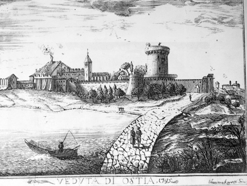
A view of the Via Ostiensis just before it reaches the borgo, seen from the east (Silvestro Appunti, 1745).
To the left is the swamp, to the right are the salt pans. Image: Pannuzi 2018, fig. 5.
In the first or second century AD, perhaps due to a major flood in 69 AD, this meander moved slightly to the south, so that the road could not be used any longer. It is still not clear how this problem was solved. Probably a new zig-zag road was constructed to the south, in the area of the borgo, where some stretches of road have been identified. Confirmation still needs to be found that the road was not continued in a straight line, as another viaduct.

A stretch of a Roman road in the Parco dei Ravennati, to the east of the borgo.
Photo: Pannuzi 2018, fig. 10.
OSTIABORGO |
Brick arches of the aqueduct have been preserved in the mediaeval borgo of the modern village Ostia Antica. They can be seen behind a small concrete soccer field on Via Gesualdo.

Remains of the aqueduct in the mediaeval borgo of Ostia Antica.
Photo: Jan Theo Bakker.
Literature
- B. Andreae, "Processus consularis. Zur Deutung des Sarkophags von Acilia", Opus Nobile. Festschrift Jantzen, Wiesbaden 1969, 1-13.
- S. Aurigemma, "Mosaici da Casal di Statua e da Risaro", BdA 46 (1961), 150-159.
- M. Bedello Tata - S. Falzone - S. Focagnolo S., "Rinvenimento di un sistema di acquedotti in localita Malafede-Infermeria (Acilia)", Archeologia Laziale 12,2 (1995), 429-438.
- M. Bedello Tata - E. Bukowiecki et al., "Le acque e gli acquedotti nel territorio Ostiense e Portuense. Ritrovamenti e ricerche recenti", MEFRA 118 (2006), 463-526.
- R. Bianchi Bandinelli, "Sarcofago da Acilia con la designazione di Gordiano III", BdA 39 (1954), 200-220.
- F. Bisconti - G. Ferri, La strada di Paolo. La via Ostiense dalle origini alla cristianizzazione, 2018.
- Ch. Bruun, "Vespasian's Aqvae Dvctvs in Ostia and Ostia's Relationship with Rome", CQ 68,1 (2018), 220-231.
- A. Buccellato - F. Coletti F. - E. Giannini, "Sistematizzazione dei dati archeologici nel suburbio ostiense tra la valle di Malafede e i lembi dello Stagno", MEFRA 130,2 (2018), 315-320.
- C. Buzzetti - P. Virgili, "Via Ostiense", BullCom 90,2 (1985), 432-435.
- C. Buzzetti, "Via Ostiense", BullCom 93,2 (1989-1990), 507-508.
- C. Caldarini, "Mezzo millennio di storia romana a Casal Bernocchi-Malafede. I risultati degli scavi 2015", MEFRA 130,2 (2018), 289-294.
- J.-P. Callu, "Symmaque. Lettres", Collection Budé, Tome I-II-III, Paris 1972-1982-1995.
- L. Chioffi, "Ancora inediti dal sepolcreto di S. Paolo sulla via Ostiense. Un campione significativo dei suoi occupanti: i 'Ciartii'", BullCom 93,2 (1989-1990), 391-406.
- L. Chiumenti - F. Bilancia [G. Tomassetti - F. Tomassetti], "Via Laurentina-Ostiense", La campagna romana antica, medioevale e moderna, volume 5, Firenze 1979 (1897).
- Comune di Roma, information leaflets: Municipio X.
- M.R. Di Mino, "Un mosaico a soggetto marino dalla villa rustica di Risaro", BdA 60 (1975), 103-104.
- S. Falzone - P. Olivanti - A. Pellegrino, "La necropoli di Fralana (Acilia)", Culto dei morti e costumi funerari romani (M. Heinzelmann et al. eds.), Palilia 8 (2001), 127-138.
- M. Fascitiello - A. Pellegrino, "Il suburbio ostiense: fattorie e ville rustiche nell'area del Dragoncello", Centre and Periphery in the Ancient World 2, Merida 2015, 1049-1053.
- M. Fascitiello, "The Excavation of Villa C at Casale Dragoncello (Acilia)", Journal of Fasti Online, Folder 403 (2018).
- C. Fea, Relazione di un viaggio ad Ostia e alla villa di Plinio detta Laurentino, Roma 1802.
- P. Izzi - A. Pellegrino, "Acilia. Recupero e musealizzazione di un tratto dell'antica via Ostiense", Archeologia e Giubileo (F. Filippi ed.), Roma 2001, 375-378.
- R. Lanciani, Le acque e gli acquedotti, Roma 1880.
- C. La Rocca, "Via Ostiense", BullCom 109 (2008), 361-380.
- S. Lorenzatti (ed.), Ostia. Storia Ambiente Itinerari, Ostia 2007.
- S. Lorenzatti et al., "Ritrovamenti archeologici nel corso delle opere di sistemazione del canale Bagnolo (via Ostiense Km 22,700). Fase I (2016)", MEFRA 130,2 (2018), 295-301.
- M. Marcelli, "Memorie dell'antico nel paesaggio pre-industriale della via ostiense: rinvenimenti archeologici e demolizioni fra otto e novecento", Bollettino dell'Unione Storia ed Arte 6 (2011), 77-88.
- R. Matteucci et al., "Via Ostiense", BullCom 103 (2002), 364-377.
- G. Olcese - X. Gonzalez-Muro - A. Pellegrino, "La villa A di Dragoncello (Acilia): la ripresa degli scavi", Journal of Fasti Online, Folder 398 (2017).
- G. Olcese et al., "La villa A di Dragoncello (Acilia). Alcuni dati dello scavo e dallo studio dei reperti", MEFRA 130,2 (2018), 325-340.
- S. Pannuzi - F. Cenciotti - G. Bertolani et al., "Ostia antica. Indagini archeologiche lungo la via Ostiense", BullCom 107 (2006), 192-216.
- S. Pannuzi et al., "Via Ostiense", BullCom 114 (2013), 366-423.
- S. Pannuzi, "Viabilità e utilizzo del territorio. Il suburbio sud-orientale di Ostia alla luce dei recenti rinvenimenti archeologici", Ricerche su Ostia e il suo territorio, Rome 2018.
- A. Pellegrino, "Ville rustiche a Dragoncello (Acilia)", Archeologia laziale 5 (1983), 76-84.
- A. Pellegrino, "Due iscrizioni tardo-repubblicane del territorio di Ostia (Acilia - Dragoncello)", Miscellanea Greca e Romana 9 (1984), 155-162, Roma.
- A. Pellegrino, "Scavi a Dragoncello e a Casalbernocchi (Acilia)", Archeologia laziale 6 (1984), 194-198.
- A. Pellegrino, "Le ville di Dragoncello (Acilia)", Il Tevere: un'antica via per il Mediterraneo, Roma 1986, 297-298.
- A. Pellegrino, "Ville rustiche, fattorie ed altri monumenti di età romana nel territorio di Acilia: un problema di musealizzazione ed integrazione col territorio", I siti archeologici, un problema di musealizzazione all'aperto, Roma 1988, 35-40.
- A. Pellegrino, "La viabilità del territorio ostiense in età imperiale", Viae publicae romanae, Roma 1991, 70-75.
- A. Pellegrino et al., "Scavo di edificio rustico e di un sepolcreto di età repubblicana ad Acilia". Archeologia Laziale 11 (1993), 141-148.
- A. Pellegrino et al., "Insediamento rustico di età repubblicana ed imperiale a Fralana (Acilia)", Archeologia Laziale 12 (1995), 417-427.
- A. Pellegrino, "Via Ostiense: rinvenimento di un viadotto ad Acilia", Strade romane. Ponti e viadotti (L. Quilici - S. Quilici Gigli edd.), Roma 1996, 81-83.
- A. Pellegrino, "La necropoli della via Ostiense ad Acilia", Culto dei morti e costumi funerari romani (M. Heinzelmann et al. eds.), Palilia 8 (2001), 123-126.
- A. Pellegrino, "I mosaici di alcune ville rustiche del territorio ostiense. Acilia, località Dragoncello", Atti AISCOM, Ravenna 2001, 233-246.
- A. Pellegrino, "Il territorio ostiense nella tarda età repubblicana", Ostia, Cicero, Gamala, Feasts and the Economy, Portsmouth 2004, 33-46.
- A. Pellegrino, "Il contesto territoriale", Ceramiche da contesti repubblicani del territorio di Ostia, Roma 2016, 65-67.
- L. Quilici, "I ponti della Via Ostiense", Strade romane. Ponti e viadotti (L. Quilici - S. Quilici Gigli edd.), Roma 1996, 53-79.
- C. Sánchez-Moreno Ellart, "About the meaning of 'colens in asse' in CIL VI, 33840: A contrast to colonus partiarius?", Zeitschrift der Savigny-Stiftung für Rechtsgeschichte, Römische Abteilung, 128 (2011), 388-405 (libellus of Geminius Eutyches).
- V. Scrinari - M.A. Ricciardi, La Civiltà dell'Acqua in Ostia Antica, Roma 1996.
- S. Serra, "Via Ostiense. Via Portuense", Antiche strade. Lazio, Roma 2007.
- F. Tella, "Un acquedotto degli inizi dell'eta imperiale nei pressi del Casale di Malafede: contributo alla discussione sul primo sistema di adduzione idrica di Ostia antica", Geologia dell'Ambiente 3 suppl. (2017), 260-264.
- A. Tomassetti, "Via Ostiense", BullCom 105 (2004), 442-443, 445.