![]()
![]()
Isola Sacra - South-east part - The mystery of the round building
Introduction
In 1995 a map was published of the east part of Ostia's Trastevere, the area on the other side of the Tiber, to the north of the excavations, by Angelo Pellegrino et al. (Pellegrino - Olivanti - Panariti 1995). It shows an area that was enclosed by a branch of the Tiber until 1557. In that year the river changed its course during a flood. The branch that can be seen on the map became a swamp and was gradually filled with earth. Today it is known as the Dead River (Fiume Morto). On the map a round structure can be seen in the south-east part of this area. The plan of this structure is an interpretation by Pellegrino of aerial photographs (a photo mosaic) taken in 1911 from a balloon, published by E.J. Shepherd in 2006. According to Pellegrino it is clearly visible.
 |
The map published in 1995. The round structure is marked C.
The old branch of the Tiber is indicated by interrupted lines.
Image: Pellegrino-Olivanti-Panariti 1995, fig. 1.
The structure (marked C on the map) is very large, apparently with a diameter of c. 65 metres. It has the shape of a donut, with cross-walls to the south-west and north-east, suggesting rooms or compartments. A few lines suggest a further circular structure inside the donut, and a round perimetral wall. A single line and dot to the north-west represent some other feature.

Before 1557 the Tiber ran below and to the right of this field.
This stony ploughed field is where the round structure is supposed to be buried.
The interpretation of the aerial photographs
Ostia negative C2707 is a print (15 x 23 cm) of a photograph taken of the balloon photo (c. 80 x 120 cm) that hangs on the wall of the library of Ostia. The structure is seen as shown below (left: original; right: enhanced):
 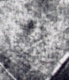  |
The structure does indeed seem to emerge. We seem to get confirmation for the rooms in the donut in the south-west part (there seems to be a drainage channel crossing the structure).
Geophysical research
Since the 1950's intensive ploughing took place in the area. On two occasions geophysical research took place here. The results of the first campaign were published in 1995 by Antonia Arnoldus-Huyzendveld. The structure could not be seen through geo-electric measurements (distance 2 meters, measure depth 1.5 meters) (Arnoldus-Huyzendveld - Paroli 1995). The authors concluded: "The results of the measurements in this area are not indicative of the presence of the round structure: values are intermediate, between 20 and 30 Ohm*m. ... An explanation of the low values (apart from a non-existence of the structure) could be its burial at a depth of more than 1.5 meters. We recommend trenches."
The results of the second campaign are known through the May 2004 newsletter of the International Society for Archaeological Prospection (R. Gabrielli - T. Iuliano - P. Mauriello - D. Peloso - D. Monna, "Application of resistivity survey in the Mediterranean area", p. 11-12). The sampling step was 1 metre. During this campaign most of the structure seems to have been outside the prospected area. The accompanying figure of the results is confusing, because the structure is projected on two different topographic maps. There is no textual conclusion. Nevertheless, the rooms in the north-east part seem to be confirmed.
 |
The area was visited in November 2007 by Jan Theo Bakker and Antonia Arnoldus-Huyzendveld. It had been ploughed recently. On the entire area we found a damp, sticky layer, containing a huge amount of Roman and mediaeval objects, such as large fragments of pottery and very thick glass. This may well be a dump of the 1938-1942 excavations, and it may explain why the remote sensing does not provide any information. We must conclude that there is no unequivocal evidence for the existence of the structure.
What was the structure?
Was this perhaps the amphitheatre of Ostia? At the end of 2006 Prof. Jorgen Christian Meyer, University of Bergen, Norway, suggested that the structure might be a mausoleum. Obvious parallels for the size are then the mausolea of Augustus and Hadrianus in Rome. Next, Prof. Meyer and Jan Theo Bakker contemplated the hypothesis that it is the mausoleum of Claudius. The place of burial of most Emperors from the first two centuries is known. Exceptions are Claudius and Vespasianus. Ancient literature is silent about their tombs, and the inscriptions related to the mausoleum of Augustus do not mention them (see H. von Hesberg - S. Panciera, "Das Mausoleum des Augustus: der Bau und seine Inschriften", 1994). J.C. Rolfe in his article "On Suetonius, Nero, 33.1" (American Journal of Philology 1933, 362-367) finds evidence in ancient literature that Claudius was not buried in the mausoleum of Augustus.
A mausoleum of Claudius in that bend of the Tiber would be in a brilliant position. It would be in accordance with the importance of Claudius' work in the harbour and throw an interesting light on his personality. We know that he respected tradition and his family, but also had a business-like attitude, relying often on freedmen for example. A mausoleum in Ostia would be a complement of the mausoleum of Augustus, pointing out that the Julio-Claudian family had done important work for the population in Rome not only in Rome itself, but also in the harbour. We may note also the isolation and therefore accentuation of the monument, on the Isola Sacra. Of great importance is also the visibility for people coming to Ostia from Rome: they would see the mausoleum from the Via Ostiensis, and they would see the many tow-boats, leaving the harbour with cargoes, at the foot of the mausoleum. It is the location of the presumed structure that makes the hypothesis so attractive. Had it been further to the north or west, the impact would not be comparable.
Of interest are finally three drawings of the mediaeval town, anonymous (16th century), by C. Riegel (1692), and M. Merian (1688). They depict the situation before the 1557 flood. To the left, where the mausoleum would have been, is a large, round "capanna" (hut), that is conceivably in the remains of the mausoleum. Note that on the topographical map this part of the Isola Sacra is called "capanna murata". A huge, round hut built inside and on top of ancient ruins on the other side of the Isola Sacra, near Portus, was visited by Von Bonstetten in the early 19th century. This hut can be seen on a map in the Catasto Alessandrino.
The area in which the presumed structure is located is protected. Indeed, "we recommend trenches".

The area of the supposed structure, seen from the south.
Photo: Roberto Padoan.
![]()
![]()