![]()
![]()
Isola Sacra - The Via Flavia
The Via Flavia was discovered in 1879. It led in a straight line from the Fossa Traiana in the north to the Tiber in the south. At the north end the road ended with a paved square, and was continued by the Bridge of Matidia that spanned the Fossa Traiana. At the south end the road reached the Tiber opposite the area of Tor Boacciana.
The road was 10.5 meters wide. There was a double carriageway used by wagons. It was paved with polygonal basalt blocks, in which deep wheel ruts have been preserved. A sidewalk ran along the paved section. It had a rammed gravel surface. A coin of Galba (68-69 AD) provides a terminus post quem for the construction, which can be placed somewhere in the last decades of the first century AD.

The Via Flavia in the Isola Sacra necropolis. Photo: Parco Archeologico di Ostia Antica.
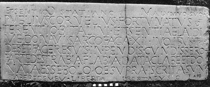
The name Via Flavia is documented in a funerary inscription, and most likely refers to a Flavian Emperor: Vespasianus, Titus or Domitianus. It has also been suggested that the name (not to be confused with the date of construction) was given in the early fourth century, and refers to Constantine, an Emperor of the so-called second Flavian dynasty. He named part of Portus "Civitas Flavia Constantiniana". The latter hypothesis must be rejected however, because the tomb with the inscription belongs to the last decades of the second century AD, as indicated by a brick stamp.
 |
|
D(is) M(anibus) ET SENTIO STATIANO ALVMNO SVO PVBLIVS CORNELIVS FORTVNATVS TERENTIO BITALINI ET SENTIAE LAIDI ME DONAVI SARCOFAGA N(umero) XII IN QIBUS TRIA DEBET FACERE SVIS INPENDIS CVNDISSERO PARTE DESTRA BIA FLABIA DATA CLABE ET DO NATA ESSE BOLO QE SUPRA ISCRITA SVN ET AB EREDE MEV LIBERTI LIBERTABVSQ(ue) |
| Inscription from tomb 16 of the Isola Sacra necropolis, mentioning the Bia Flabia. W. 0.78, h. 0.29. EDR101446. Photo: EDCS-28300341. |
![]()
![]()